Accueil > SPIP > Navigation > Image Map jQuery « MapHilight » > « Image Map » JQuery MapHilight (zones illuminées au survol de la souris) de (...)
 « Image Map » JQuery MapHilight (zones illuminées au survol de la souris) de David Lynch appliqué à « La Carte des 26 cantons suisses » dans SPIP
mercredi 1er février 2017, par
Notez cet articleJQuery maphilight (Map Hilight) est le script jquery créé par David Lynch. Ce script permet aux rédacteurs d’associer des zones de clic aux images. De plus, fait important, ce script permet de changer les couleurs, transparences, épaisseurs de traits et d’ajouter une ombre paramétrée pour les zones cliquables au survol de la souris, tout cela sans nécessiter la connaissance de javascript / jquery.
Dans cet article nous appliquons le code de l’exemple maphilight « demo_world » à l’image « La Carte des 26 cantons suisses ».
Préambule
En standard dans le squelette de SPIP 3.1 la largeur maximale des images est fixée à 672 pixel, en particulier dans le fichier article.html, lorsque cette largeur est plus grande elle est réduite à 672 pixels avec l’utilisation du filtre |image_reduire. Pour plus d’informations on consultera l’article Réduire la dimension des images avec le filtre |image_reduirelargeur,hauteur.
L’exemple maphilight « simple demo » appliqué ici à l’image « Les 26 cantons suisses » est totalement opérationnel sur grand écran avec une souris. Ce n’est pas le cas avec l’utilisation des tablettes (Ipad, etc.) et smartphones (Iphone, etc.).
Pour plus d’information sur le Plugin JQuery MapHilight de David Lynch on consultera l’article : « Image Map » JQuery MapHilight (zones illuminées au survol de la souris) de David Lynch appliqué à l’image « Louve Capitoline » dans SPIP.
MapHilight des 26 cantons suisses
Les informations fournies pour cette image interactive des 26 cantons suisses sont tirées de l’article Wikipédia : Canton suisse.
Source image : Document Wikipedia Canton suisse SVG.
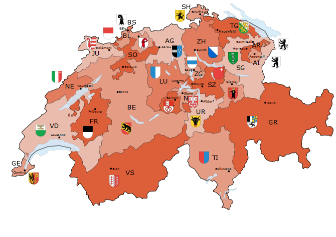
Les 26 zones cliquables ont été créées avec le filtre du logiciel GIMP : Filtres, Web, Image cliquable Web...
Cette « Image MapHilight » de la carte des 26 cantons de la Suisse présente sous forme graphique interactive (Infobulle qui apparaissent au survol de la souris) toute l’information présentée dans le tableau ci-dessous.
L’attribution des couleurs & opacités des contours et des fonds, épaisseurs des contours et ombres paramétrées pour les zones réactives est appliquée en une fois à l’ensemble des zones réactives dans le javascript avec la série d’instructions :
        fade: false,

        fillColor: '008800',

        strokeColor: '0000ff',

        strokeWidth: 2,

        fillOpacity: 0.2,

        shadow: true,

        shadowX: 7,

        shadowY: 7,

        shadowRadius: 6,

        shadowColor: '000000',

        shadowOpacity: 0.5,

        shadowPosition: 'outside',

        shadowFrom: false
Ce qui donne :
<script type="text/javascript">$(function() {

$('.map').maphilight({

        fade: false,

        fillColor: '008800',

        strokeColor: '0000ff',

        strokeWidth: 2,

        fillOpacity: 0.2,

        shadow: true,

        shadowX: 7,

        shadowY: 7,

        shadowRadius: 6,

        shadowColor: '000000',

        shadowOpacity: 0.5,

        shadowPosition: 'outside',

        shadowFrom: false

});

});</script>
La documentation du plugin maphilight et présentée dans l’article « jQuery maphilight documentation », lequel propose quatre exemples d’utilisation du plugin. Ici nous appliquons le code de l’exemple « A map of the world » à l’image « Les 26 cantons suisses ».
Données cantonales
Source : Wikipédia Canton suisse
| No | Abr. | CANTON | Depuis | Chef-lieu | Population [décembre 2014] | Population [en % du total suisse] | Superficie [en km²] | Superficie [en % du total suisse] | Densité [en hab./km²] | Nombre de Communes | Langue officielle |
| 1 | AG | Argovie (Aargau) | 1803 | Aarau | 635797 | 7.8 | 1403.73 | 3.4 | 452.9 | 220 | allemand |
| 2 | AI | Appenzell Rhodes-Intérieures (Appenzell Innerrhoden) | 1513 | Appenzell | 15778 | 0.2 | 172.52 | 0.4 | 91.5 | 6 | allemand |
| 3 | AR | Appenzell Rhodes-Extérieures (Appenzell Ausserrhoden) | 1513 | Herisau | 53017 | 0.7 | 242.86 | 0.6 | 218.3 | 20 | allemand |
| 4 | BE | Berne (Bern) | 1353 | Berne | 1001281 | 12.3 | 5959.44 | 14.4 | 168 | 383 | allemand ; français |
| 5 | BL | Bâle-Campagne (Basel-Landschaft) | 1501 | Liestal | 275536 | 3.4 | 517.56 | 1.3 | 532.4 | 86 | allemand |
| 6 | BS | Bâle-Ville (Basel-Stadt) | 1501 | Bâle | 187898 | 2.3 | 37 | 0.1 | 5078.3 | 3 | allemand |
| 7 | FR | Fribourg (Freiburg) | 1481 | Fribourg | 303377 | 3.7 | 1670.7 | 4 | 181.6 | 167 | français ; allemand |
| 8 | GE | Genève | 1815 | Genève | 490578 | 6 | 282.48 | 0.7 | 1736.7 | 45 | français |
| 9 | GL | Glaris (Glarus) | 1352 | Glaris | 38479 | 0.5 | 685.3 | 1.7 | 56.1 | 3 | allemand |
| 10 | GR | Grisons (Graubünden ; Grischun ; Grigioni) | 1803 | Coire | 192621 | 2.4 | 7105.44 | 17.2 | 27.1 | 178 | allemand ; romanche ; italien |
| 11 | JU | Jura | 1979 | Delémont | 71738 | 0.9 | 838.55 | 2 | 85.6 | 64 | français ; allemand (1 commune) |
| 12 | LU | Lucerne (Luzern) | 1332 | Lucerne | 377610 | 4.6 | 1493.44 | 3.6 | 252.8 | 87 | allemand |
| 13 | NE | Neuchâtel (Neuenburg) | 1815 | Neuchâtel | 176241 | 2.2 | 802.93 | 1.9 | 219.5 | 53 | français |
| 14 | NW | Nidwald (Nidwalden) | 1291 | Stans | 41024 | 0.5 | 275.9 | 0.7 | 148.7 | 11 | allemand |
| 15 | OW | Obwald (Obwalden) | 1291 | Sarnen | 35585 | 0.4 | 490.59 | 1.2 | 72.5 | 7 | allemand |
| 16 | SG | Saint-Gall (St. Gallen) | 1803 | Saint-Gall | 478907 | 5.9 | 2025.54 | 4.9 | 236.4 | 85 | allemand |
| 17 | SH | Schaffhouse (Schaffhausen) | 1501 | Schaffhouse | 76356 | 0.9 | 298.42 | 0.7 | 255.9 | 27 | allemand |
| 18 | SO | Soleure (Solothurn) | 1481 | Soleure | 261437 | 3.2 | 790.49 | 1.9 | 330.7 | 121 | allemand |
| 19 | SZ | Schwytz (Schwyz) | 1291 | Schwytz | 146730 | 1.8 | 906.92 | 2.2 | 161.8 | 30 | allemand |
| 20 | TG | Thurgovie (Thurgau) | 1803 | Frauenfeld | 244330 | 3 | 991.02 | 2.4 | 246.5 | 80 | allemand |
| 21 | TI | Tessin (Ticino) | 1803 | Bellinzone | 335720 | 4.1 | 2812.2 | 6.8 | 119.4 | 157 | italien |
| 22 | UR | Uri | 1291 | Altdorf | 35422 | 0.4 | 1076.57 | 2.6 | 32.9 | 20 | allemand |
| 23 | VD | Vaud | 1803 | Lausanne | 755369 | 9.3 | 3212.03 | 7.8 | 235.2 | 318 | français |
| 24 | VS | Valais (Wallis) | 1815 | Sion | 327011 | 4 | 5224.25 | 12.7 | 62.6 | 141 | français ; allemand |
| 25 | ZG | Zoug (Zug) | 1352 | Zoug | 113105 | 1.4 | 238.69 | 0.6 | 473.9 | 11 | allemand |
| 26 | ZH | Zurich (Zürich) | 1351 | Zurich | 1371007 | 16.8 | 1729 | 4.2 | 792.9 | 171 | allemand |
Code utilisé
<html>
<head>
<meta charset="utf-8">
<title>jQuery maphilight documentation</title>
<script type="text/javascript" src="lib/maphilight/main.js" charset="UTF-8"></script><script type="text/javascript" src="lib/maphilight/jquery.min.js"></script>
<script type="text/javascript" src="lib/maphilight/jquery.maphilight.min.js"></script>
<script type="text/javascript">$(function() {
$('.map').maphilight({
fade: false,
fillColor: '008800',
strokeColor: '0000ff',
strokeWidth: 2,
fillOpacity: 0.2,
shadow: true,
shadowX: 7,
shadowY: 7,
shadowRadius: 6,
shadowColor: '000000',
shadowOpacity: 0.5,
shadowPosition: 'outside',
shadowFrom: false
});
});</script>
</head>
<img class="map" src="IMG/png/Suisse-26-Cantons-670x433px2-ecusson.png" width="670" height="474" border="0" usemap="#world">
<map name="world">
<area shape="poly" coords="46,316,53,321,59,326,64,331,68,329,71,332,70,334,59,340,46,352,32,353,24,351,26,343,23,342,23,339,30,335,43,332,44,328,42,327,42,324" alt="GE : Genève" href="https://fr.wikipedia.org/wiki/Canton_de_Gen%C3%A8ve" target="_blank" title="GE : Genève, depuis : 1815,
Chef-lieu : Genève,
Population (décembre 2014) : 490'578,
Population (en % du total suisse) : 6.0,
Superficie (en km²) : 282.48,
Superficie (en % du total suisse) : 0.7,
Densité (en hab./km²) : 1'736.7,
Nombre de Communes : 45,
Langue officielle : français." />
<area shape="poly" coords="46,316,50,309,38,297,39,287,49,275,48,271,43,264,68,240,84,229,94,223,89,217,90,209,93,207,104,205,115,199,118,199,131,190,135,202,137,207,139,217,145,222,148,221,145,229,149,233,153,227,151,221,150,220,157,221,159,213,157,213,157,208,159,204,157,199,153,195,174,178,176,180,180,181,180,189,184,197,181,201,180,205,176,209,175,202,169,196,169,192,166,191,161,194,167,203,168,208,168,213,166,213,166,219,160,224,160,230,151,241,151,246,146,245,140,248,141,262,150,263,157,266,149,273,145,271,143,273,146,279,151,280,155,274,162,280,167,280,168,292,170,291,179,282,185,282,193,273,198,271,204,270,205,279,202,283,203,290,197,293,200,298,198,307,201,315,197,319,197,324,186,336,173,346,170,336,164,327,164,319,152,303,146,302,142,302,141,295,123,291,96,292,75,301,62,309,57,323" alt="VD : Vaud" href="https://fr.wikipedia.org/wiki/Canton_de_Vaud" target="_blank" title="VD : Vaud, depuis : 1803,
Chef-lieu : Lausanne,
Population (décembre 2014) : 755'369,
Population (en % du total suisse) : 9.3,
Superficie (en km²) : 3'212.03,
Superficie (en % du total suisse) : 7.8,
Densité (en hab./km²) : 235.2,
Nombre de Communes : 318,
Langue officielle : français." />
<area shape="poly" coords="142,302,152,302,164,321,164,327,170,337,174,347,193,331,197,324,197,319,201,315,205,315,207,310,212,307,215,314,231,305,242,307,248,303,246,298,253,298,259,291,271,301,288,285,297,284,307,277,307,271,315,267,339,276,357,270,363,264,364,255,371,249,373,258,370,263,372,270,378,274,375,282,367,281,366,290,354,296,353,298,357,303,356,306,345,314,339,320,332,320,324,330,332,337,335,347,333,352,328,359,321,360,315,363,317,373,310,382,298,383,294,388,293,397,284,397,280,394,271,395,263,386,255,387,250,384,245,385,246,389,241,390,236,391,236,395,224,402,211,398,206,405,199,405,198,411,193,406,189,407,186,412,176,397,177,390,172,389,173,384,160,366,158,366,156,371,153,371,153,366,155,364,154,355,142,354,138,351,142,346,141,339,148,328,149,322,141,316,137,309,141,308" alt="VS : Valais" href="https://fr.wikipedia.org/wiki/Canton_du_Valais" target="_blank" title="VS : Valais (Wallis), depuis : 1815,
Chef-lieu : Sion,
Population (décembre 2014) : 327'011,
Population (en % du total suisse) : 4.0,
Superficie (en km²) : 5'224.25,
Superficie (en % du total suisse) : 12.7,
Densité (en hab./km²) : 62.6,
Nombre de Communes : 141,
Langue officielle : français, allemand." />
<area shape="poly" coords="93,206,93,199,89,192,96,184,111,177,116,178,121,169,126,168,126,166,125,163,129,159,133,158,134,153,135,151,139,151,149,142,152,142,155,145,155,152,153,154,154,157,163,152,173,151,184,158,183,164,182,166,178,166,171,170,170,175,165,175,157,181,152,180,151,188,147,188,147,192,144,192,135,202,131,188,130,188,118,200,115,199,102,207" alt="NE : Neuchâtel" href="https://fr.wikipedia.org/wiki/Canton_de_Neuch%C3%A2tel" target="_blank" title="NE : Neuchâtel (Neuenburg), depuis : 1815,
Chef-lieu : Neuchâtel,
Population (décembre 2014) : 176'241,
Population (en % du total suisse) : 2.2,
Superficie (en km²) : 802.93,
Superficie (en % du total suisse) : 1.9,
Densité (en hab./km²) : 219.5,
Nombre de Communes : 53,
Langue officielle : français." />
<area shape="poly" coords="160,195,165,190,168,191,170,196,175,201,175,205,174,208,176,208,180,203,181,200,184,197,180,187,180,180,184,180,190,179,200,175,203,178,203,179,199,182,201,196,209,199,219,199,220,206,219,207,215,205,213,208,217,210,213,222,212,222,213,229,211,233,218,236,222,241,222,249,215,249,214,259,217,261,215,264,209,263,204,269,200,271,197,270,185,281,180,282,173,288,168,292,167,280,162,280,155,274,151,280,147,279,144,275,143,271,147,271,149,273,157,266,150,263,141,263,140,248,146,245,151,245,151,241,161,229,159,225,165,220,166,214,168,213,167,208,167,204,159,195,155,197,159,204,156,213,158,213,158,219,156,220,152,220,150,220,152,226,149,232,142,233,137,231,136,228,145,229,148,221,143,220,138,214,141,210,145,209,156,198" alt="FR : Fribourg" href="https://fr.wikipedia.org/wiki/Canton_de_Fribourg" target="_blank" title="FR : Fribourg (Freiburg), depuis : 1481,
Chef-lieu : Fribourg,
Population (décembre 2014) : 303'377,
Population (en % du total suisse) : 3.7,
Superficie (en km²) : 1'670.70,
Superficie (en % du total suisse) : 4,
Densité (en hab./km²) : 181.6,
Nombre de Communes : 167,
Langue officielle : français, allemand." />
<area shape="poly" coords="155,144,155,152,153,154,153,158,162,152,171,151,172,151,183,158,183,165,178,166,171,170,170,175,172,176,175,176,175,180,174,184,167,190,169,196,175,202,176,208,180,204,180,200,184,197,180,186,180,180,190,178,200,175,202,180,200,183,201,195,207,199,219,199,219,206,218,207,215,205,213,208,217,209,214,222,212,223,211,226,214,229,210,233,218,236,222,240,223,249,214,249,214,259,216,260,216,264,209,264,204,269,206,280,202,283,202,291,197,294,198,296,200,298,199,300,198,307,200,307,201,316,205,316,207,310,210,306,213,307,215,313,226,306,232,305,241,306,248,303,246,299,254,298,259,292,265,295,270,300,287,285,294,286,302,281,308,278,307,270,314,267,322,270,325,270,329,272,334,275,342,275,350,273,356,271,361,265,363,256,369,246,366,241,376,241,374,231,374,224,365,223,362,221,352,228,347,225,341,225,335,228,332,228,326,223,318,221,309,223,302,214,292,210,291,201,293,200,294,196,293,194,296,191,299,190,304,180,303,175,298,177,293,169,293,155,295,151,294,147,294,141,289,130,290,121,284,120,280,123,273,123,268,117,259,119,253,118,256,125,267,139,261,146,255,146,251,142,245,142,244,150,238,154,237,159,233,160,232,157,226,158,223,153,231,151,233,145,241,145,237,134,226,141,219,133,232,124,239,121,246,117,249,110,246,110,241,114,225,113,225,109,215,116,205,118,201,114,195,116,196,118,194,120,194,125,181,126,177,134,172,134,172,139,165,139,161,143" alt="BE : Berne" href="https://fr.wikipedia.org/wiki/Canton_de_Berne" target="_blank" title="BE : Berne (Bern), depuis : 1353,
Chef-lieu : Berne,
Population (décembre 2014) : 1'001'281,
Population (en % du total suisse) : 12.3,
Superficie (en km²) : 5'959.44,
Superficie (en % du total suisse) : 14.4,
Densité (en hab./km²) : 168,
Nombre de Communes : 383,
Langue officielle : allemand, français." />
<area shape="poly" coords="367,290,370,287,375,288,378,292,379,314,374,320,374,322,377,325,377,331,387,338,400,356,413,362,416,359,423,364,427,359,435,371,432,371,432,376,426,380,425,384,430,383,437,390,440,397,446,408,442,415,447,415,453,416,455,420,458,419,458,412,460,407,466,402,460,399,457,399,455,392,453,386,456,384,456,381,454,379,454,372,465,369,465,362,464,359,476,348,467,336,467,331,463,323,464,319,464,313,467,311,468,301,470,297,466,295,466,293,467,293,467,288,461,284,456,276,456,268,461,265,458,262,454,259,451,260,448,260,447,251,439,253,440,261,437,266,425,267,418,263,415,265,409,263,405,265,399,265,391,264,387,263,384,267,384,272,384,273,378,274,375,280,367,281,366,286" alt="TI : Tessin" href="https://fr.wikipedia.org/wiki/Canton_du_Tessin" target="_blank" title="TI : Tessin (Ticino), depuis : 1803,
Chef-lieu : Bellinzone,
Population (décembre 2014) : 335'720,
Population (en % du total suisse) : 4.1,
Superficie (en km²) : 2'812.20,
Superficie (en % du total suisse) : 6.8,
Densité (en hab./km²) : 119.4,
Nombre de Communes : 157,
Langue officielle : italien." />
<area shape="poly" coords="149,140,153,136,154,132,163,127,162,117,171,113,173,108,176,108,179,105,176,99,169,99,165,101,154,101,155,98,163,86,170,81,167,75,169,71,181,75,186,72,198,76,195,77,194,85,206,88,214,85,218,85,220,88,225,91,230,97,233,97,236,101,246,101,247,108,251,109,251,112,246,110,243,114,226,113,225,108,216,116,211,117,204,117,200,115,195,115,195,118,193,120,193,125,186,126,181,125,176,134,172,134,171,139,164,138,160,142,155,145,152,143,149,142" alt="JU : Jura" href="https://fr.wikipedia.org/wiki/Canton_du_Jura" target="_blank" title="JU : Jura, depuis : 1979,
Chef-lieu : Delémont,
Population (décembre 2014) : 71'738,
Population (en % du total suisse) : 0.9,
Superficie (en km²) : 838.55,
Superficie (en % du total suisse) : 2,
Densité (en hab./km²) : 85.6,
Nombre de Communes : 64,
Langue officielle : français, allemand (1 commune)." />
<area shape="poly" coords="476,348,481,347,481,342,489,334,488,326,495,316,495,312,494,310,494,301,489,296,488,292,492,290,492,283,495,279,507,278,506,282,511,287,513,284,516,279,520,280,520,286,518,291,518,297,521,302,520,307,527,311,527,314,533,321,543,323,549,322,556,322,555,313,559,311,567,314,571,309,578,308,587,306,590,304,597,313,595,315,595,323,603,328,604,335,606,337,607,335,614,336,620,330,610,317,613,305,619,301,615,298,616,295,606,298,601,292,601,281,603,273,611,264,610,260,615,259,621,255,627,255,630,252,634,260,631,263,631,265,636,264,639,272,656,270,659,273,664,267,664,256,659,253,656,252,655,253,651,253,650,242,655,236,653,233,659,228,656,221,660,217,663,210,662,200,665,193,664,189,662,186,660,186,655,186,656,181,652,178,645,179,645,183,641,188,641,192,632,193,630,197,630,204,624,204,618,209,609,209,607,206,604,207,600,201,592,195,590,196,578,191,577,181,580,177,577,173,573,174,568,172,562,169,555,169,549,165,543,165,539,164,534,166,532,164,528,164,527,166,522,165,529,179,527,179,519,191,519,199,511,198,504,196,488,193,481,198,481,201,476,200,469,207,465,201,460,202,457,208,457,212,456,214,446,216,441,217,440,216,435,215,433,219,430,219,429,223,429,225,427,228,426,230,424,232,422,231,421,230,418,231,418,235,412,239,408,239,406,243,408,247,406,249,405,250,405,253,408,259,408,263,414,265,418,263,424,267,429,266,438,265,440,261,439,253,447,252,448,259,453,258,461,264,458,268,456,274,459,281,467,287,467,293,466,296,468,296,468,310,465,314,465,318,463,323,467,330,466,336" alt="GR : Grisons" href="https://fr.wikipedia.org/wiki/Canton_des_Grisons" target="_blank" title="GR : Grisons (Graubünden, Grischun, Grigioni), depuis : 1803,
Chef-lieu : Coire,
Population (décembre 2014) : 192'621,
Population (en % du total suisse) : 2.4,
Superficie (en km²) : 7'105.44,
Superficie (en % du total suisse) : 17.2,
Densité (en hab./km²) : 27.1,
Nombre de Communes : 178,
Langue officielle : allemand, romanche, italien." />
<area shape="poly" coords="370,56,370,62,369,64,363,69,363,73,362,74,361,79,363,82,362,86,364,85,364,88,368,91,368,93,364,98,364,100,367,101,368,109,372,111,374,109,372,114,368,116,370,127,374,132,380,133,384,133,387,131,393,131,399,134,400,140,403,140,405,143,408,143,407,139,412,132,423,129,423,125,427,123,432,125,442,122,443,116,442,116,448,111,449,104,444,98,444,93,436,90,438,86,435,75,438,68,435,65,429,65,427,60,430,60,425,55,424,52,417,52,417,49,422,47,423,49,428,41,420,38,415,43,411,42,408,41,406,36,408,33,406,31,401,31,400,34,399,35,402,39,401,42,398,42,398,48,396,51,394,52,394,56,392,56,392,60,391,60,387,56,386,55,381,55,378,57" alt="ZH : Zurich" href="https://fr.wikipedia.org/wiki/Canton_de_Zurich" target="_blank" title="ZH : Zurich (Zürich), depuis : 1351,
Chef-lieu : Zurich,
Population (décembre 2014) : 1'371'007,
Population (en % du total suisse) : 16.8,
Superficie (en km²) : 1'729.00,
Superficie (en % du total suisse) : 4.2,
Densité (en hab./km²) : 792.9,
Nombre de Communes : 171,
Langue officielle : allemand." />
<area shape="poly" coords="276,63,281,71,283,70,285,70,288,64,292,64,300,76,303,77,304,83,308,82,309,87,310,91,316,96,313,109,304,110,298,107,299,110,290,121,290,128,306,127,306,119,314,120,314,127,321,127,321,123,327,123,326,127,334,127,335,132,340,130,341,122,347,119,354,120,357,137,363,149,372,146,371,133,369,127,371,126,368,116,373,114,374,109,372,111,369,109,369,102,366,100,365,98,369,93,368,91,366,90,363,84,362,79,363,74,364,72,364,68,370,63,371,56,366,58,360,57,353,49,345,48,343,46,336,52,333,51,328,56,326,59,323,58,319,60,307,60,305,63,301,60,298,54,294,53,294,54,288,54,285,61" alt="AG : Argovie" href="https://fr.wikipedia.org/wiki/Canton_d%27Argovie" target="_blank" title="AG : Argovie (Aargau), depuis : 1803,
Chef-lieu : Aarau,
Population (décembre 2014) : 635'797,
Population (en % du total suisse) : 7.8,
Superficie (en km²) : 1'403.73,
Superficie (en % du total suisse) : 3.4,
Densité (en hab./km²) : 452.9,
Nombre de Communes : 220,
Langue officielle : allemand." />
<area shape="poly" coords="290,128,290,128,306,127,305,119,313,119,313,128,320,127,320,123,326,123,326,127,334,126,334,130,340,130,341,121,347,118,352,120,357,139,363,148,371,146,376,153,368,163,369,166,377,166,382,172,383,177,354,176,349,174,343,178,343,182,340,183,336,182,333,186,333,189,328,197,326,195,321,198,322,206,317,210,320,216,318,221,309,223,302,214,292,209,292,200,294,200,293,194,300,190,303,184,305,179,301,177,297,173,293,168,294,159,296,150,294,140,291,133,290,128,290,127,290,127" alt="LU : Lucerne" href="https://fr.wikipedia.org/wiki/Canton_de_Lucerne" target="_blank" title="LU : Lucerne (Luzern), depuis : 1332,
Chef-lieu : Lucerne,
Population (décembre 2014) : 377'610,
Population (en % du total suisse) : 4.6,
Superficie (en km²) : 1'493.44,
Superficie (en % du total suisse) : 3.6,
Densité (en hab./km²) : 252.8,
Nombre de Communes : 87,
Langue officielle : allemand." />
<area shape="poly" coords="499,125,497,125,491,121,482,122,480,120,481,109,482,106,480,106,478,103,485,93,494,93,497,91,504,90,504,87,511,88,512,85,521,83,525,78,526,78,539,85,536,87,533,84,530,85,530,86,532,91,529,91,529,87,526,86,522,87,522,89,522,92,521,94,520,97,521,102,519,103,515,104,513,99,506,96,500,96,501,100,494,106,495,111,494,115,498,121" alt="AR : Appenzell Rhodes-Extérieures" href="https://fr.wikipedia.org/wiki/Canton_d%27Appenzell_Rhodes-Ext%C3%A9rieures" target="_blank" title="AR : Appenzell Rhodes-Extérieures (Appenzell Ausserrhoden), depuis : 1513,
Chef-lieu : Herisau,
Population (décembre 2014) : 53'017,
Population (en % du total suisse) : 0.7,
Superficie (en km²) : 242.86,
Superficie (en % du total suisse) : 0.6,
Densité (en hab./km²) : 218.3,
Nombre de Communes : 20,
Langue officielle : allemand." />
<area shape="poly" coords="520,103,516,104,513,100,506,97,500,96,501,101,495,106,495,110,495,111,494,115,498,120,498,124,505,128,512,125,519,116,520,111,522,109,521,104,520,100,521,94,523,86,526,86,529,88,529,91,531,91,532,90,529,87,529,84,533,84,535,86,536,87,536,89,533,89,532,91,530,91,528,93,523,94,521,93,520,97,521,102,521,103" alt="AI : Appenzell Rhodes-Intérieures" href="https://fr.wikipedia.org/wiki/Canton_d%27Appenzell_Rhodes-Int%C3%A9rieures" target="_blank" title="AI : Appenzell Rhodes-Intérieures (Appenzell Innerrhoden), depuis : 1513,
Chef-lieu : Appenzell,
Population (décembre 2014) : 15'778,
Population (en % du total suisse) : 0.2,
Superficie (en km²) : 172.52,
Superficie (en % du total suisse) : 0.4,
Densité (en hab./km²) : 91.5,
Nombre de Communes : 6,
Langue officielle : allemand." />
<area shape="poly" coords="424,127,425,126,427,126,428,131,436,132,445,131,447,132,447,137,450,138,463,149,469,148,477,152,478,162,476,164,471,166,472,168,477,171,480,168,483,168,485,170,486,175,486,185,485,186,489,190,488,194,490,196,492,193,499,196,507,196,518,200,518,201,519,191,526,180,529,179,521,163,527,154,523,142,522,132,528,123,528,120,536,111,543,98,548,98,549,95,547,94,545,83,543,79,538,79,535,72,529,62,521,58,515,67,519,71,519,73,515,75,514,71,515,68,514,67,512,72,509,71,508,75,504,75,503,72,499,70,499,66,493,67,490,68,491,70,492,69,494,68,496,71,496,76,492,76,489,78,486,78,483,76,480,77,473,71,470,75,464,76,458,73,451,75,452,76,457,82,457,87,451,87,445,97,449,105,448,112,445,112,443,116,444,116,443,121,433,126,427,125,428,124,425,124,423,125" alt="SG : Saint-Gall" href="https://fr.wikipedia.org/wiki/Canton_de_Saint-Gall" target="_blank" title="SG : Saint-Gall (St. Gallen), depuis : 1803,
Chef-lieu : Saint-Gall,
Population (décembre 2014) : 478'907,
Population (en % du total suisse) : 5.9,
Superficie (en km²) : 2'025.54,
Superficie (en % du total suisse) : 4.9,
Densité (en hab./km²) : 236.4,
Nombre de Communes : 85,
Langue officielle : allemand." />
<area shape="poly" coords="444,98,450,90,450,85,455,86,457,82,451,76,457,72,463,76,469,76,473,72,480,76,481,75,485,78,489,78,496,76,496,71,495,69,490,70,490,68,499,66,500,70,505,75,508,76,508,72,512,72,514,67,515,69,514,72,515,75,519,74,519,72,521,58,502,47,491,40,478,40,472,38,468,35,463,35,455,34,442,41,439,41,430,35,423,35,417,32,413,31,407,32,405,36,407,40,410,42,416,42,420,38,428,41,426,46,424,49,417,48,417,52,423,52,423,55,428,57,430,59,428,60,429,64,435,65,437,66,437,70,435,74,435,78,436,83,439,86,436,90,436,91,444,93" alt="TG : Thurgovie" href="https://fr.wikipedia.org/wiki/Canton_de_Thurgovie" target="_blank" title="TG : Thurgovie (Thurgau), depuis : 1803,
Chef-lieu : Frauenfeld,
Population (décembre 2014) : 244'330,
Population (en % du total suisse) : 3.0,
Superficie (en km²) : 991.02,
Superficie (en % du total suisse) : 2.4,
Densité (en hab./km²) : 246.5,
Nombre de Communes : 80,
Langue officielle : allemand." />
<area shape="poly" coords="406,32,406,28,413,27,413,29,415,28,415,26,423,26,424,24,427,24,427,26,435,29,435,31,434,31,433,34,436,36,436,39,430,36,427,35,424,35,427,32,426,29,423,29,423,26,415,26,414,22,416,21,415,18,412,17,410,19,409,14,404,10,405,16,404,17,402,16,400,10,395,8,393,9,392,14,384,15,380,17,377,21,378,25,372,28,371,33,372,37,375,39,378,39,379,42,381,41,386,40,386,44,379,48,377,49,377,53,381,54,382,55,387,55,391,61,392,61,392,56,394,56,394,52,392,52,392,47,386,44,386,39,390,37,397,36,399,36,400,31,403,32" alt="SH : Schaffhouse" href="https://fr.wikipedia.org/wiki/Canton_de_Schaffhouse" target="_blank" title="SH : Schaffhouse (Schaffhausen), depuis : 1501,
Chef-lieu : Schaffhouse,
Population (décembre 2014) : 76'356,
Population (en % du total suisse) : 0.9,
Superficie (en km²) : 298.42,
Superficie (en % du total suisse) : 0.7,
Densité (en hab./km²) : 255.9,
Nombre de Communes : 27,
Langue officielle : allemand." />
<area shape="poly" coords="252,58,250,61,246,61,241,64,241,68,243,70,242,73,244,75,244,78,243,81,232,80,230,83,236,87,237,89,235,93,230,91,225,90,226,86,219,86,219,88,230,98,233,98,234,94,239,94,241,97,246,96,247,91,252,91,252,88,257,88,259,81,256,76,264,75,272,78,269,85,268,90,265,92,261,92,262,98,263,100,272,99,277,106,282,106,282,104,290,99,296,94,302,95,305,92,305,89,304,88,303,77,298,77,291,64,287,64,287,68,284,71,282,71,281,68,275,63,269,65,265,65,263,63,261,60,259,61,259,64,258,65,253,65,252,62" alt="BL : Bâle-Campagne" href="https://fr.wikipedia.org/wiki/Canton_de_B%C3%A2le-Campagne" target="_blank" title="BL : Bâle-Campagne (Basel-Landschaft), depuis : 1501,
Chef-lieu : Liestal,
Population (décembre 2014) : 275'536,
Population (en % du total suisse) : 3.4,
Superficie (en km²) : 517.56,
Superficie (en % du total suisse) : 1.3,
Densité (en hab./km²) : 532.4,
Nombre de Communes : 86,
Langue officielle : allemand." />
<area shape="poly" coords="265,50,263,49,261,52,257,52,253,56,252,58,252,62,253,64,258,66,259,65,258,61,261,60,262,57,264,56,265,54,263,54" alt="BS : Bâle-Ville" href="https://fr.wikipedia.org/wiki/Canton_de_B%C3%A2le-Ville" target="_blank" title="BS : Bâle-Ville (Basel-Stadt), depuis : 1501,
Chef-lieu : Bâle,
Population (décembre 2014) : 187'898,
Population (en % du total suisse) : 2.3,
Superficie (en km²) : 37.00,
Superficie (en % du total suisse) : 0.1,
Densité (en hab./km²) : 5'078.3,
Nombre de Communes : 3,
Langue officielle : allemand." />
<area shape="poly" coords="234,94,234,92,236,91,236,88,230,83,232,80,242,80,244,77,244,74,241,73,240,76,236,76,234,73,231,73,229,74,230,75,233,77,232,80,230,82,225,86,225,90,230,90,231,92,234,92,234,93,234,94,239,93,241,97,246,95,246,92,252,92,252,89,257,88,259,82,257,76,264,75,266,77,272,77,272,81,268,86,268,89,265,92,261,92,262,100,272,99,277,106,282,106,282,104,290,100,295,94,302,94,305,92,305,88,303,88,304,84,305,82,307,82,309,86,310,88,309,90,316,96,313,109,304,109,298,106,297,110,290,120,283,120,282,123,279,122,277,124,272,124,267,116,260,119,258,119,254,118,254,124,254,125,258,126,261,133,267,139,266,141,265,142,267,144,270,143,270,146,269,147,265,148,265,145,266,144,264,142,262,145,255,145,251,142,246,142,245,146,244,149,242,152,237,154,237,159,233,159,232,157,230,157,226,159,222,154,223,151,232,152,231,149,233,145,239,146,240,143,238,140,238,135,234,138,231,137,231,139,226,143,221,137,220,132,232,126,231,123,237,122,238,119,242,117,246,117,251,112,251,108,246,108,246,100,241,100,241,101,237,101,234,99,233,97,234,95" alt="SO : Soleure" href="https://fr.wikipedia.org/wiki/Canton_de_Soleure" target="_blank" title="SO : Soleure (Solothurn), depuis : 1481,
Chef-lieu : Soleure,
Population (décembre 2014) : 261'437,
Population (en % du total suisse) : 3.2,
Superficie (en km²) : 790.49,
Superficie (en % du total suisse) : 1.9,
Densité (en hab./km²) : 330.7,
Nombre de Communes : 121,
Langue officielle : allemand." />
<area shape="poly" coords="367,240,367,244,369,247,372,249,373,257,369,264,373,270,376,274,378,275,384,273,384,267,387,263,398,264,401,266,405,266,408,263,408,258,404,253,404,249,406,246,406,240,411,239,417,234,417,231,419,230,420,230,421,232,425,232,429,224,428,219,434,216,435,215,434,208,444,205,446,202,446,198,443,193,433,198,430,201,430,196,429,196,428,189,418,190,411,194,409,186,399,187,396,179,392,182,392,187,385,193,379,195,378,202,378,206,382,207,382,209,379,212,379,220,381,222,381,225,374,225,374,232,375,235,375,242,370,242,369,241" alt="UR : Uri" href="https://fr.wikipedia.org/wiki/Canton_d%27Uri" target="_blank" title="UR : Uri, depuis : 1291,
Chef-lieu : Altdorf,
Population (décembre 2014) : 35'422,
Population (en % du total suisse) : 0.4,
Superficie (en km²) : 1'076.57,
Superficie (en % du total suisse) : 2.6,
Densité (en hab./km²) : 32.9,
Nombre de Communes : 20,
Langue officielle : allemand." />
<area shape="poly" coords="318,221,318,219,320,218,320,214,317,212,317,209,321,207,321,199,325,195,326,195,328,197,330,193,333,189,333,186,336,183,343,184,348,181,354,183,355,185,353,192,354,193,360,193,358,216,367,224,369,223,369,220,364,215,363,212,363,204,365,204,366,207,367,207,370,205,371,207,377,206,382,207,382,209,378,212,378,218,381,222,381,225,374,225,373,224,369,223,361,220,351,228,347,225,338,225,335,228,332,228,326,223,321,222" alt="OW : Obwald" href="https://fr.wikipedia.org/wiki/Canton_d%27Obwald" target="_blank" title="OW : Obwald (Obwalden), depuis : 1291,
Chef-lieu : Sarnen,
Population (décembre 2014) : 35'585,
Population (en % du total suisse) : 0.4,
Superficie (en km²) : 490.59,
Superficie (en % du total suisse) : 1.2,
Densité (en hab./km²) : 72.5,
Nombre de Communes : 7,
Langue officielle : allemand." />
<area shape="poly" coords="377,206,378,196,382,195,392,187,392,182,394,182,390,178,382,181,377,180,378,176,375,173,367,173,360,178,356,176,349,175,344,177,342,177,344,182,348,181,354,183,355,187,354,193,360,193,358,216,363,221,367,224,370,221,364,215,363,211,363,204,365,204,365,207,368,207,370,205,372,207,375,207" alt="NW : Nidwald" href="https://fr.wikipedia.org/wiki/Canton_de_Nidwald" target="_blank" title="NW : Nidwald (Nidwalden), depuis : 1291,
Chef-lieu : Stans,
Population (décembre 2014) : 41'024,
Population (en % du total suisse) : 0.5,
Superficie (en km²) : 275.90,
Superficie (en % du total suisse) : 0.7,
Densité (en hab./km²) : 148.7,
Nombre de Communes : 11,
Langue officielle : allemand." />
<area shape="poly" coords="378,152,378,153,376,153,376,151,373,151,370,147,370,133,368,129,368,127,370,124,372,131,378,133,383,132,387,130,393,131,399,134,400,140,403,140,404,143,407,143,408,141,409,144,409,146,407,152,404,157,398,157,396,158,392,158,392,156,388,156,386,157,383,157,382,153,380,152,378,152" alt="ZG : Zoug" href="https://fr.wikipedia.org/wiki/Canton_de_Zoug" target="_blank" title="ZG : Zoug (Zug), depuis : 1352,
Chef-lieu : Zoug,
Population (décembre 2014) : 113'105,
Population (en % du total suisse) : 1.4,
Superficie (en km²) : 238.69,
Superficie (en % du total suisse) : 0.6,
Densité (en hab./km²) : 473.9,
Nombre de Communes : 11,
Langue officielle : allemand." />
<area shape="poly" coords="383,176,383,172,376,166,372,166,367,165,367,163,376,153,381,152,386,157,387,156,392,156,392,158,395,158,398,157,404,156,405,153,407,152,409,145,409,142,407,139,412,133,422,130,429,132,434,133,445,130,447,132,447,138,450,138,450,142,447,150,448,152,448,154,445,155,445,158,447,159,447,162,443,167,438,167,438,173,443,178,443,181,448,185,446,191,443,193,432,199,431,201,428,189,418,189,410,194,409,186,399,187,396,179,390,179,383,181,381,180,382,177,384,177,384,176" alt="SZ : Schwytz" href="https://fr.wikipedia.org/wiki/Canton_de_Schwytz" target="_blank" title="SZ : Schwytz (Schwyz), depuis : 1291,
Chef-lieu : Schwytz,
Population (décembre 2014) : 146'730,
Population (en % du total suisse) : 1.8,
Superficie (en km²) : 906.92,
Superficie (en % du total suisse) : 2.2,
Densité (en hab./km²) : 161.8,
Nombre de Communes : 30,
Langue officielle : allemand." />
<area shape="poly" coords="448,184,443,180,443,176,438,172,438,166,442,166,447,161,447,158,445,157,445,154,448,153,448,151,446,149,450,137,463,148,469,147,474,148,478,151,478,161,476,164,471,164,471,168,475,169,481,167,483,167,485,169,486,178,486,185,488,189,488,192,486,193,481,197,481,200,475,200,469,205,464,201,461,201,460,201,457,211,455,212,448,215,440,216,440,214,435,214,434,207,443,204,447,201,446,197,443,192,446,190,446,187" alt="GL : Glaris" href="https://fr.wikipedia.org/wiki/Canton_de_Glaris" target="_blank" title="GL : Glaris (Glarus), depuis : 1352,
Chef-lieu : Glaris,
Population (décembre 2014) : 38'479,
Population (en % du total suisse) : 0.5,
Superficie (en km²) : 685.30,
Superficie (en % du total suisse) : 1.7,
Densité (en hab./km²) : 56.1,
Nombre de Communes : 3,
Langue officielle : allemand." />
</map>
</html>Sources
- Canton suisse
https://fr.wikipedia.org/wiki/Canton_suisse